


State Route 4, U.S. Route 250, Sandusky-Columbus corridor part of study

Gov. Mike DeWine and the Ohio Department of Transportation (ODOT) recently released the results of an 18-month study looking at transportation investments to support economic growth and development in the state, including State Route 4 and U.S. 250.
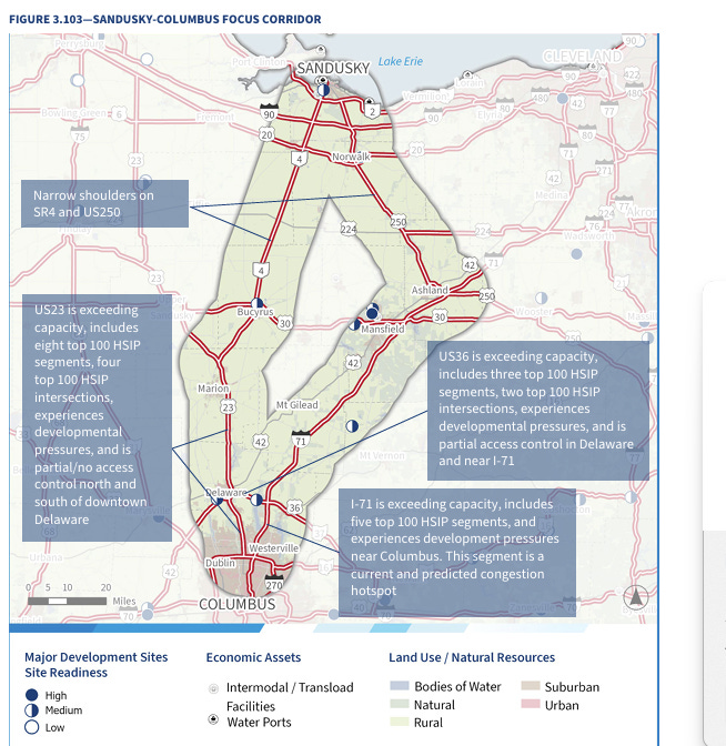
"The study recommended evaluating potential improvements to State Route 4 and U.S. 250 to address constraints through city and town centers such as Bucyrus and Norwalk," a news release providing details stated. "Improvements could include widening narrow shoulders and adding turn lanes in rural areas."
Overall, ODOT analyzed risks associated with congestion in seven geographic and economic regions and studied interregional connections along six focus corridors.
These corridors included Toledo to Columbus and Sandusky to Columbus, as specified in Ohio House Bill 23. They specifically examined how these corridors will meet travel needs over the next 10, 20, and 30 years.
This corridor includes State Route 4, U.S. Route 250, Interstate 71, and U.S. Route 23. It connects Sandusky and resort areas along Lake Erie with communities in Delaware and Franklin counties.
Sandusky’s economy relies on tourism and manufacturing, while the Delaware County economy is expected to continue to diversify.
Population growth along the corridor has been mixed.
The Port of Sandusky and its proximity to Interstate 90 provide growth opportunities for logistics-related businesses. Population is forecasted to continue declining in rural areas between Sandusky and Marion.
Delaware and northern Columbus suburbs will continue to grow and generate strong travel demand on the corridor.
Several corridor segments are experiencing congestion, while others are nearing capacity. U.S. Route 23 and Interstate 71 between U.S. Route 36 and Interstate 270 have the highest number of future congestion risks.
Approximately 50% of the mileage along the corridor has no access control and numerous driveways.
These conflict points can lead to crashes and congestion, which degrade the safety and reliability of the travel route. The corridor includes over 20% of the state’s top 100 highway safety improvement locations, with priority segments along Interstate 71.
The full report, including appendices and a digital interactive mapping tool can be found at transportation.ohio.gov/statewidestudy